
In our August-September issue (#84) of Old Africa we showed some photos of Mt Ololokwe, which I had climbed with my son Reid and his wife and four of my grandchildren in July. We used those photos as our History Mystery contest. We had an amazing response and we received the most correct answers of any History Mystery Contest – 16. Dick Moss from Nairobi was chosen as the winner, having mapped the the mountain in 1959 and then climbed it in the mid-1970s. Amazingly, we also received a correct answer from Alec Abell, who had climbed Mt Ololokwe with Dick Moss in 1974! We only had space in our magazine to print six answers. But so many answers were good that we didn’t want our readers to miss out on them. So we’re offering some of those answers here as “runners-up” for our contest. We plan to send all our runners-up a free book from Old Africa. Dick Moss will receive his first prize of a 3000/- gift certificate to Text Book Centre. We encourage you to read the latest issue of Old Africa and enter our newest History Mystery Contest.
Mt Ololokwe History Mystery Contest from Issue 84 Runners-up answers
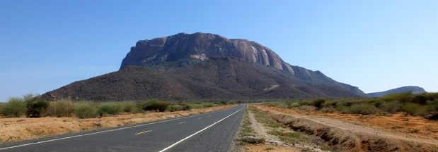
How could I fail to recognise my favourite NFD mountain of which we have an attractive oil painting hanging on our wall. It has two names. Ol Lolokwe and Ol Donyo Sabachi and is in Samburu District just north of the Samburu National Park on the Uaso Nyiro river and just off the new Tarmac road to Marsabit.
I have climbed the mystery mountain three times. The first time in 1975 with a friend who worked for the Survey Dept of Kenya. The large scale government published map of the flat summit showed no detail and he wished to fill this in. This he did and marked amongst the beautiful cedar forest a permanent spring of crystal clear water. We noticed in the water there were numerous leeches which indicated wild animals drank there. We also came across a freshly killed black rhino minus horn up there. This had been covered with fresh green branches to obscure it from the eyes of vultures of which are numerous on the cliffs.
Those were the days and how we miss beautiful Kenya.
Alec Abell, Harborough, UK
This mountain is now generally known as Ololokwe, but on early maps it was shown as Donyo Sabache. I note that on a 1966 Survey of Kenya Topographical Map it is marked as Ol Doinyo Sabachi (Lolokwi.) It is about 27 kilometres as the crow flies north-west from Archer’s Post. The main road from Isiolo via Archer’s Post and Laisamis to Marsabit goes just East of Lolokwe; skirting the bottom of the hills. Some six or seven kilometres south of Lolokwe there is a road turnoff to the North-West going to Wamba and Maralal.
The distinctive cliffs of this mountain are very well known and appear on many paintings and photographs. I first saw the cliffs from near Timau in late 1956 when I was with Survey of Kenya. From suitable hilltops on a clear day one could see a fantastic view of the fabled NFD and many hills and ranges – with Ololokwe showing up as the most obvious. A few months later we were based at Isiolo and one Sunday took some time off to explore up to Ololokwe and beyond. We saw lots of game and birds but I do not remember seeing any humans or domestic livestock. The last time I drove past Ololokwe I distinctly remember the most horrible corrugations in the road. Hard to believe there is a paved road there now.
I have not climbed Ololokwe, as I am not a rock-climber, and I do not particularly like heights. If I had wanted to climb up Ololokwe I would not have avoided the cliffs and gone round to the north-east side where there aren’t any. I once heard a rumour of someone getting to the top on a motorbike.
John Vaughan, Naivasha
The mystery photo shows Mt Ololokwe, usually visited by the Samburu to pray for rain and healthy cattle. Its name, Olo Olokwe, when directly translated to English simply means sacred mountain. The mountain also attracts a significant number of tourists each year.
Tiras Waiyaki, Nairobi
The mystery mountain is Mt Ololokwe situated on the Isiolo-Marsabit Road some kilometres beyond Archer’s Post where the Wamba/Maralal Road branches off to the left and the Marsabit Road takes a broad right hand bend. It is the sacred mountain of the Samburu and is deemed to be the home of God. I have many happy memories of the Samburu area and Mt Ololokwe as I have spent many school holidays exploring the area with various friends.
In April 1974, my wife and I, accompanied by two VSOs (Jonathan Barnes and Pete Smith, both based in Eldoret) camped on Champagne Ridge for a few days watching the animals come to us rather than the other way round. On April 20th we made a valiant attempt to climb Ololokwe but only made it about half-way as we tackled it from the wrong angle and too late in the day.
In August 1980, I accompanied a small group of staff and students from Starehe Boys’ School on a camping trip in Samburu. The camp was just a few metres off the main Isiolo-Archer’s Post Road, about 10 kilometres from Isiolo (the area has now been denuded). We were privileged to be visited by Wilfred Thesiger, ‘The Last Great Nomad.’ One objective was to climb Ololokwe. We got guides and an AP who took us round to the back of the mountain where we picked up cattle tracks which led comfortably to the top. Apart from the magnificent view, I remember being shown a crystal clear pool of water in a small grotto. The water was cool and pure.
On the same camping trip, we explored through Shaba looking for Chandler’s Falls. We found an extinct volcano, called Magadi, I think. The rim was only a few meters above the surrounding area but the crater was deeper. The local people were busy collecting salt from the bottom and transporting it to the top on very narrow, steep paths, using donkeys. On the way back to Shaba and camp we found Chandler’s Falls.
Paul Scott, Eldoret
The mountain is Ololokwe and the plant in the picture on the right is most likely Encephalartos tegulaneus, which is known to grow in that area. We climbed Ololokwe many years ago as I was searching for a plant (Streptocarpus exertus) that I knew grew on the mountain in a shady wet spot near a waterfall. The guide had absolutely no idea about a waterfall, so we had an exhausting time wandering around and eventually gave up.
Mrs Gaye Aikman, Naro Moru
The mountain in your mystery contest is the sacred Samburu mountain, Ol Donyo Sabachi (Ololokwe). This must be one of the most photographed landmarks in Kenya. It is hard to resist photographing it whenever one is near it and observes its changing moods. Over the years while organising the Rhino Charge we have held several events either near it or where we drive past it. Here are two photos.
Belinda Levitan, Nairobi
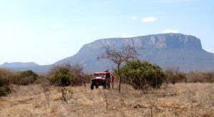
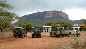
Rhino Charge competitor in Kalama Conservancy (left) and Rhino Charge recce team in Namunyak Conservancy (right). Photos from Belinda Levitan
Recent Comments